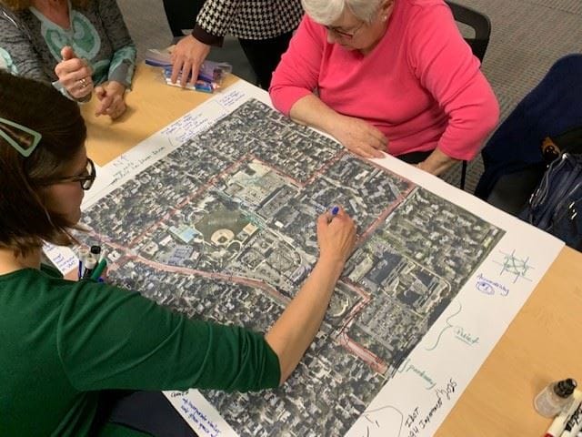
A draft plan to reshape South La Grange Road with a new traffic signal, pedestrian crossings, and mixed-use development guidelines is now in its final rounds of review, backed by survey data from nearly 600 residents and shaped by months of public debate over safety, flooding, and affordability.
The South La Grange Road Corridor Plan, developed by the Chicago Metropolitan Agency for Planning in partnership with the Village, covers the stretch from 47th Street to Plainfield Road. The Steering Committee reviewed the draft at its May 28 meeting. One more committee session is scheduled for June before the Village Board takes up the plan for adoption in July.
A signal at 51st Street tops the list
The plan's headline safety recommendation: work with the Illinois Department of Transportation to install a signalized intersection at 51st Street, a location dictated by IDOT spacing requirements. In the community survey, 75% of respondents backed a new signal somewhere on the corridor, making it the top-ranked traffic intervention. Another 68% supported a HAWK pedestrian crossing, a beacon-activated signal that stops traffic for pedestrians.
"Almost 600 people took the survey over a roughly 10-day period," CMAP project manager Todd Vanadilok told the Steering Committee. "It showed a great care for community."
The survey ran in late March and early April. Speed-limit reductions, despite frequent calls for them in written comments, ranked low as a preferred intervention. Respondents said they doubted a lower posted limit would change driver behavior. Curb bump-outs and raised medians also drew skepticism, with residents questioning whether the road's width could accommodate them.
Residents push safety, cite school crossings
Pedestrian safety has dominated public comment since the study launched in fall 2025. At the January Steering Committee meeting, resident Jane Sivrovich told the panel, "Twenty years ago, a student died and I would hate to see another death."
At the April 21 meeting, resident Anne Bennett noted the corridor falls within School District 105 and argued students need safe crossings. Mason Blenkhorn, a parent who described biking to Sedgwick Park with his young daughter as feeling "useless" because crossing the street is "a very involved process," asked the committee to include a combination of attainable measures rather than an all-or-nothing approach.
The draft plan responds with a recommendation to formulate a Safe Routes to School Plan and to pursue restrictions on larger trucks using the corridor.
Affordability and flooding concerns
Not everyone is satisfied with the direction. Committee Member Volkman said at the April 21 meeting that the survey's preferred building materials would hinder affordable housing by being too expensive, and that traffic interventions lacked sufficient detail. Committee Member Egan echoed the cost concern, requesting low-cost, easy-to-implement recommendations alongside larger interventions.
Flooding drew sharp comments from residents. Mark Muehler told the committee the drainage system "is always failing" and that streetscaping is "useless until flooding is addressed." Resident John Pluto referenced flood-control concerns extending through 2034 and a reservoir project, and cited a 2010 KLOA report that had already recommended lowering the speed limit, questioning why that recommendation went unimplemented for 16 years.
CMAP's Jules Voigt acknowledged the tension at the May 28 meeting, noting "there is a balancing act between the need for improvements vs. the demand for improvements vs. potential congestion impacts."
Redevelopment without eminent domain
The draft identifies four "Opportunity Areas" for potential redevelopment. The stretch between 47th and 48th Streets scored highest due to building age. The area between 52nd and 53rd Streets drew resident interest in mixed-use development. Survey respondents broadly favored commercial and mixed-use buildings with flat roofs, large windows, masonry, and neutral tones.
CMAP's Todd Vanadilok stressed that eminent domain is not part of the plan. The goal, he said, is to educate property owners on available resources, not to push them to sell. CMAP's Jordan Nash added that "just because a block is highlighted does not mean there will be immediate change."
A near-term strategy calls for codifying some design guidelines into the Village's Zoning Code during an update expected to begin later in 2026. Potential funding sources include Special Service Areas, Tax Increment Financing, IHDA programs, and AARP grants.
What's next
The Steering Committee meets once more in June to review a revised draft incorporating public comments collected May 19–28 on CMAP's engagement website. Village Planner Kevin Quinn confirmed a mailing will go out to residents ahead of that final meeting. The Village Board is scheduled to vote on adoption in July.